To understand this project, it helps to look up into the sky and use your own imagination: Somewhere up there at an altitude of 700 to 1320 kilometers, satellites of the European Commission and the European Space Agency (ESA) are orbiting the earth. On board: numerous sensors that continuously measure the Earth’s surface.
“We are living in a golden era of Earth observation,” says Prof. Xiaoxiang Zhu. That’s because since the European Commission and ESA have made this data available freely and without charge as part of their “Copernicus” program, science has had access to a gigantic archive of data. The challenge is to be able to read and use these heterogeneous data sets – for example, to detect natural hazards at an early stage.
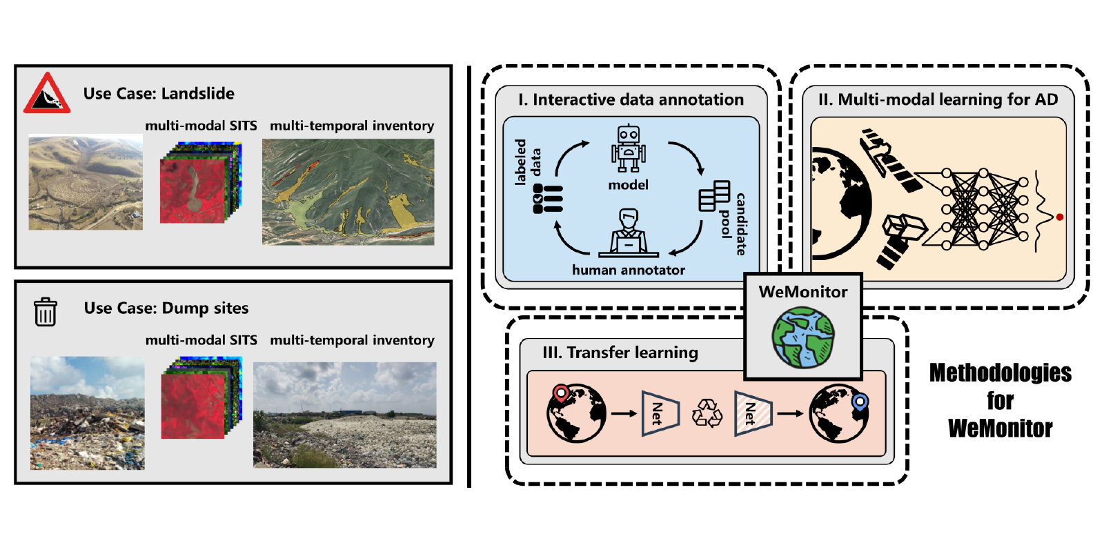
This is precisely what Prof. Xiaoxiang Zhu, who is a Professor for Data Science in Earth Observation at the Technical University of Munich and her project team, which includes researchers from the German Aerospace Center (DLR) and German Research Center for Geosciences (GFZ), have set themselves the goal of doing: tracking certain spatio-temporal anomalies on the Earth’s surface. Specifically, they are developing a model that uses satellite data and artificial intelligence to automatically monitor natural hazards and processes of change caused, for example, by landslides, deforestation, large fires, dam failures or the emergence of waste dump sites.
For this purpose, the project team is training its algorithm with small-annotated data sets – concrete examples of for instance landslides – to recognize those anomalies on the earth’s surface independently in the data pool. However, since such phenomena are very complex, the model must be able to cope with a wide range of different types of data offering complementary information. Another challenge is that landslides in Europe often look completely different from those in Asia, for example. “The model therefore needs to be able to transfer learned knowledge across geographic regions,” says Prof. Xiaoxiang Zhu.
But once it can do that, it could support and improve many fields – not just research, but also government agencies or urban planners, or risk assessment in general. It’s a model that could contribute to better environmental management. And it does so with a view from the very top.
News articles
Simplifying Earth Observation Data Access with Terragon (CONNECT blog post)
Publications
4725570
WeMonitor
1
https://helmholtz-imaging.de/apa-bold-title.csl
50
date
desc
1880
https://helmholtz-imaging.de/wp-content/plugins/zotpress/
%7B%22status%22%3A%22success%22%2C%22updateneeded%22%3Afalse%2C%22instance%22%3Afalse%2C%22meta%22%3A%7B%22request_last%22%3A0%2C%22request_next%22%3A0%2C%22used_cache%22%3Atrue%7D%2C%22data%22%3A%5B%7B%22key%22%3A%22LZSZ3VEV%22%2C%22library%22%3A%7B%22id%22%3A4725570%7D%2C%22meta%22%3A%7B%22lastModifiedByUser%22%3A%7B%22id%22%3A9722498%2C%22username%22%3A%22SaraHelmholtzImaging%22%2C%22name%22%3A%22%22%2C%22links%22%3A%7B%22alternate%22%3A%7B%22href%22%3A%22https%3A%5C%2F%5C%2Fwww.zotero.org%5C%2Fsarahelmholtzimaging%22%2C%22type%22%3A%22text%5C%2Fhtml%22%7D%7D%7D%2C%22creatorSummary%22%3A%22H%5Cu00f6hn%20et%20al.%22%2C%22parsedDate%22%3A%222025-11-11%22%2C%22numChildren%22%3A1%7D%2C%22bib%22%3A%22%26lt%3Bdiv%20class%3D%26quot%3Bcsl-bib-body%26quot%3B%20style%3D%26quot%3Bline-height%3A%201.35%3B%20padding-left%3A%201em%3B%20text-indent%3A-1em%3B%26quot%3B%26gt%3B%5Cn%20%20%26lt%3Bdiv%20class%3D%26quot%3Bcsl-entry%26quot%3B%26gt%3BH%26%23xF6%3Bhn%2C%20P.%2C%20Heidler%2C%20K.%2C%20Behling%2C%20R.%2C%20%26amp%3B%20Zhu%2C%20X.%20X.%20%282025%29.%20%26lt%3Bb%26gt%3BA%20Spatio-Temporal%20Dataset%20for%20Satellite-Based%20Landslide%20Detection%26lt%3B%5C%2Fb%26gt%3B.%20%26lt%3Bi%26gt%3BScientific%20Data%26lt%3B%5C%2Fi%26gt%3B%2C%20%26lt%3Bi%26gt%3B12%26lt%3B%5C%2Fi%26gt%3B%281%29%2C%201772.%20%26lt%3Ba%20class%3D%26%23039%3Bzp-DOIURL%26%23039%3B%20href%3D%26%23039%3Bhttps%3A%5C%2F%5C%2Fdoi.org%5C%2F10.1038%5C%2Fs41597-025-06167-2%26%23039%3B%26gt%3Bhttps%3A%5C%2F%5C%2Fdoi.org%5C%2F10.1038%5C%2Fs41597-025-06167-2%26lt%3B%5C%2Fa%26gt%3B%26lt%3B%5C%2Fdiv%26gt%3B%5Cn%26lt%3B%5C%2Fdiv%26gt%3B%22%2C%22data%22%3A%7B%22itemType%22%3A%22journalArticle%22%2C%22title%22%3A%22A%20Spatio-Temporal%20Dataset%20for%20Satellite-Based%20Landslide%20Detection%22%2C%22creators%22%3A%5B%7B%22creatorType%22%3A%22author%22%2C%22firstName%22%3A%22Paul%22%2C%22lastName%22%3A%22H%5Cu00f6hn%22%7D%2C%7B%22creatorType%22%3A%22author%22%2C%22firstName%22%3A%22Konrad%22%2C%22lastName%22%3A%22Heidler%22%7D%2C%7B%22creatorType%22%3A%22author%22%2C%22firstName%22%3A%22Robert%22%2C%22lastName%22%3A%22Behling%22%7D%2C%7B%22creatorType%22%3A%22author%22%2C%22firstName%22%3A%22Xiao%20Xiang%22%2C%22lastName%22%3A%22Zhu%22%7D%5D%2C%22abstractNote%22%3A%22The%20capability%20to%20accurately%20detect%20and%20monitor%20landslides%20is%20essential%20for%20understanding%20their%20dynamics%20and%20reducing%20associated%20risks.%20However%2C%20existing%20deep%20learning%20models%20often%20struggle%20to%20effectively%20capture%20temporal%20dynamics%20from%20satellite%20imagery%2C%20limiting%20their%20reliability%20in%20analyzing%20landslide%20behavior%20over%20time.%20To%20address%20this%20limitation%2C%20Sen12Landslides%20is%20introduced%2C%20a%20large-scale%2C%20multi-modal%2C%20multi-temporal%20dataset%20designed%20for%20satellite-based%20landslide%20monitoring%20and%20spatio-temporal%20anomaly%20detection.%20Sen12Landslides%20contains%2075%2C000%20landslide%20annotations%20from%2015%20diverse%20regions%20globally%20and%20over%2012%2C000%20patches%20derived%20from%20Sentinel-1%20SAR%2C%20Sentinel-2%20optical%20imagery%2C%20and%20Copernicus%20DEM.%20Each%20patch%20includes%20pixel-level%20annotations%20and%20precise%20event%20dates%20with%20pre-%20and%20post-event%20timestamps.%20The%20dataset%20supports%20advanced%20deep%20learning%20approaches%2C%20capturing%20spatial%20features%20and%20temporal%20changes%20critical%20for%20landslide%20detection.%20Benchmark%20experiments%20using%20established%20models%2C%20including%20U-ConvLSTM%2C%203D-UNet%2C%20and%20U-TAE%2C%20demonstrate%20the%20dataset%5Cu2019s%20utility%20for%20landslide%20detection%2C%20with%20the%20best-performing%20model%20achieving%20an%20F1-score%20exceeding%2083%25%20on%20Sentinel-2%20data.%20By%20providing%20this%20comprehensive%20resource%2C%20Sen12Landslides%20enables%20more%20robust%20model%20training%20and%20promotes%20generalization%20across%20regions%2C%20advancing%20research%20in%20Earth%20observation%20and%20geohazard%20monitoring.%22%2C%22date%22%3A%222025-11-11%22%2C%22section%22%3A%22%22%2C%22partNumber%22%3A%22%22%2C%22partTitle%22%3A%22%22%2C%22DOI%22%3A%2210.1038%5C%2Fs41597-025-06167-2%22%2C%22citationKey%22%3A%22hohnSpatioTemporalDatasetSatelliteBased2025%22%2C%22url%22%3A%22https%3A%5C%2F%5C%2Fwww.nature.com%5C%2Farticles%5C%2Fs41597-025-06167-2%22%2C%22PMID%22%3A%22%22%2C%22PMCID%22%3A%22%22%2C%22ISSN%22%3A%222052-4463%22%2C%22language%22%3A%22en%22%2C%22collections%22%3A%5B%5D%2C%22dateModified%22%3A%222026-01-19T15%3A27%3A24Z%22%7D%7D%2C%7B%22key%22%3A%22PNVUQUVC%22%2C%22library%22%3A%7B%22id%22%3A4725570%7D%2C%22meta%22%3A%7B%22lastModifiedByUser%22%3A%7B%22id%22%3A9722498%2C%22username%22%3A%22SaraHelmholtzImaging%22%2C%22name%22%3A%22%22%2C%22links%22%3A%7B%22alternate%22%3A%7B%22href%22%3A%22https%3A%5C%2F%5C%2Fwww.zotero.org%5C%2Fsarahelmholtzimaging%22%2C%22type%22%3A%22text%5C%2Fhtml%22%7D%7D%7D%2C%22creatorSummary%22%3A%22H%5Cu00f6hl%20et%20al.%22%2C%22parsedDate%22%3A%222025-10-14%22%2C%22numChildren%22%3A1%7D%2C%22bib%22%3A%22%26lt%3Bdiv%20class%3D%26quot%3Bcsl-bib-body%26quot%3B%20style%3D%26quot%3Bline-height%3A%201.35%3B%20padding-left%3A%201em%3B%20text-indent%3A-1em%3B%26quot%3B%26gt%3B%5Cn%20%20%26lt%3Bdiv%20class%3D%26quot%3Bcsl-entry%26quot%3B%26gt%3BH%26%23xF6%3Bhl%2C%20A.%2C%20H%26%23xF6%3Bhn%2C%20P.%2C%20%26amp%3B%20Zhu%2C%20X.%20X.%20%282025%29.%20%26lt%3Bb%26gt%3BTerragon%3A%20A%20Unified%20Framework%20for%20Earth%20Observation%20Data%20Cube%20Generation%26lt%3B%5C%2Fb%26gt%3B.%20%26lt%3Bi%26gt%3BJournal%20of%20Open%20Source%20Software%26lt%3B%5C%2Fi%26gt%3B%2C%20%26lt%3Bi%26gt%3B10%26lt%3B%5C%2Fi%26gt%3B%28114%29%2C%208857.%20%26lt%3Ba%20class%3D%26%23039%3Bzp-DOIURL%26%23039%3B%20href%3D%26%23039%3Bhttps%3A%5C%2F%5C%2Fdoi.org%5C%2F10.21105%5C%2Fjoss.08857%26%23039%3B%26gt%3Bhttps%3A%5C%2F%5C%2Fdoi.org%5C%2F10.21105%5C%2Fjoss.08857%26lt%3B%5C%2Fa%26gt%3B%26lt%3B%5C%2Fdiv%26gt%3B%5Cn%26lt%3B%5C%2Fdiv%26gt%3B%22%2C%22data%22%3A%7B%22itemType%22%3A%22journalArticle%22%2C%22title%22%3A%22Terragon%3A%20A%20Unified%20Framework%20for%20Earth%20Observation%20Data%20Cube%20Generation%22%2C%22creators%22%3A%5B%7B%22creatorType%22%3A%22author%22%2C%22firstName%22%3A%22Adrian%22%2C%22lastName%22%3A%22H%5Cu00f6hl%22%7D%2C%7B%22creatorType%22%3A%22author%22%2C%22firstName%22%3A%22Paul%22%2C%22lastName%22%3A%22H%5Cu00f6hn%22%7D%2C%7B%22creatorType%22%3A%22author%22%2C%22firstName%22%3A%22Xiao%20Xiang%22%2C%22lastName%22%3A%22Zhu%22%7D%5D%2C%22abstractNote%22%3A%22H%5Cu00f6hl%20et%20al.%2C%20%282025%29.%20Terragon%3A%20A%20Unified%20Framework%20for%20Earth%20Observation%20Data%20Cube%20Generation.%20Journal%20of%20Open%20Source%20Software%2C%2010%28114%29%2C%208857%2C%20https%3A%5C%2F%5C%2Fdoi.org%5C%2F10.21105%5C%2Fjoss.08857%22%2C%22date%22%3A%222025%5C%2F10%5C%2F14%22%2C%22section%22%3A%22%22%2C%22partNumber%22%3A%22%22%2C%22partTitle%22%3A%22%22%2C%22DOI%22%3A%2210.21105%5C%2Fjoss.08857%22%2C%22citationKey%22%3A%22hohlTerragonUnifiedFramework2025%22%2C%22url%22%3A%22https%3A%5C%2F%5C%2Fjoss.theoj.org%5C%2Fpapers%5C%2F10.21105%5C%2Fjoss.08857%22%2C%22PMID%22%3A%22%22%2C%22PMCID%22%3A%22%22%2C%22ISSN%22%3A%222475-9066%22%2C%22language%22%3A%22en%22%2C%22collections%22%3A%5B%5D%2C%22dateModified%22%3A%222026-01-19T15%3A28%3A09Z%22%7D%7D%2C%7B%22key%22%3A%222UZMCHY8%22%2C%22library%22%3A%7B%22id%22%3A4725570%7D%2C%22meta%22%3A%7B%22lastModifiedByUser%22%3A%7B%22id%22%3A9722498%2C%22username%22%3A%22SaraHelmholtzImaging%22%2C%22name%22%3A%22%22%2C%22links%22%3A%7B%22alternate%22%3A%7B%22href%22%3A%22https%3A%5C%2F%5C%2Fwww.zotero.org%5C%2Fsarahelmholtzimaging%22%2C%22type%22%3A%22text%5C%2Fhtml%22%7D%7D%7D%2C%22creatorSummary%22%3A%22H%5Cu00f6hn%20et%20al.%22%2C%22parsedDate%22%3A%222024-03-07%22%2C%22numChildren%22%3A1%7D%2C%22bib%22%3A%22%26lt%3Bdiv%20class%3D%26quot%3Bcsl-bib-body%26quot%3B%20style%3D%26quot%3Bline-height%3A%201.35%3B%20padding-left%3A%201em%3B%20text-indent%3A-1em%3B%26quot%3B%26gt%3B%5Cn%20%20%26lt%3Bdiv%20class%3D%26quot%3Bcsl-entry%26quot%3B%26gt%3BH%26%23xF6%3Bhn%2C%20P.%2C%20Heidler%2C%20K.%2C%20Behling%2C%20R.%2C%20%26amp%3B%20Zhu%2C%20X.%20X.%20%282024%29.%20%26lt%3Bi%26gt%3B%26lt%3Bb%26gt%3B%26lt%3Bspan%20style%3D%26quot%3Bfont-style%3Anormal%3B%26quot%3B%26gt%3BSen12Landslides%3A%20A%20Multi-modal%2C%20Large-scale%2C%20Multi-temporal%20Benchmark%20Dataset%20for%20satellite-based%20Landslide%20Monitoring%26lt%3B%5C%2Fspan%26gt%3B%26lt%3B%5C%2Fb%26gt%3B%26lt%3B%5C%2Fi%26gt%3B%20%28No.%20EGU24-3526%29.%20Copernicus%20Meetings.%20%26lt%3Ba%20class%3D%26%23039%3Bzp-DOIURL%26%23039%3B%20href%3D%26%23039%3Bhttps%3A%5C%2F%5C%2Fdoi.org%5C%2F10.5194%5C%2Fegusphere-egu24-3526%26%23039%3B%26gt%3Bhttps%3A%5C%2F%5C%2Fdoi.org%5C%2F10.5194%5C%2Fegusphere-egu24-3526%26lt%3B%5C%2Fa%26gt%3B%26lt%3B%5C%2Fdiv%26gt%3B%5Cn%26lt%3B%5C%2Fdiv%26gt%3B%22%2C%22data%22%3A%7B%22itemType%22%3A%22report%22%2C%22title%22%3A%22Sen12Landslides%3A%20A%20Multi-modal%2C%20Large-scale%2C%20Multi-temporal%20Benchmark%20Dataset%20for%20satellite-based%20Landslide%20Monitoring%22%2C%22creators%22%3A%5B%7B%22creatorType%22%3A%22author%22%2C%22firstName%22%3A%22Paul%22%2C%22lastName%22%3A%22H%5Cu00f6hn%22%7D%2C%7B%22creatorType%22%3A%22author%22%2C%22firstName%22%3A%22Konrad%22%2C%22lastName%22%3A%22Heidler%22%7D%2C%7B%22creatorType%22%3A%22author%22%2C%22firstName%22%3A%22Robert%22%2C%22lastName%22%3A%22Behling%22%7D%2C%7B%22creatorType%22%3A%22author%22%2C%22firstName%22%3A%22Xiao%20Xiang%22%2C%22lastName%22%3A%22Zhu%22%7D%5D%2C%22abstractNote%22%3A%22%22%2C%22reportNumber%22%3A%22EGU24-3526%22%2C%22reportType%22%3A%22%22%2C%22institution%22%3A%22Copernicus%20Meetings%22%2C%22date%22%3A%222024-03-07%22%2C%22DOI%22%3A%2210.5194%5C%2Fegusphere-egu24-3526%22%2C%22ISBN%22%3A%22%22%2C%22citationKey%22%3A%22hohnSen12LandslidesMultimodalLargescale2024%22%2C%22url%22%3A%22https%3A%5C%2F%5C%2Fmeetingorganizer.copernicus.org%5C%2FEGU24%5C%2FEGU24-3526.html%22%2C%22ISSN%22%3A%22%22%2C%22language%22%3A%22en%22%2C%22collections%22%3A%5B%5D%2C%22dateModified%22%3A%222026-02-05T10%3A31%3A13Z%22%7D%7D%5D%7D
Höhn, P., Heidler, K., Behling, R., & Zhu, X. X. (2025).
A Spatio-Temporal Dataset for Satellite-Based Landslide Detection.
Scientific Data,
12(1), 1772.
https://doi.org/10.1038/s41597-025-06167-2
Höhl, A., Höhn, P., & Zhu, X. X. (2025).
Terragon: A Unified Framework for Earth Observation Data Cube Generation.
Journal of Open Source Software,
10(114), 8857.
https://doi.org/10.21105/joss.08857
Höhn, P., Heidler, K., Behling, R., & Zhu, X. X. (2024).
Sen12Landslides: A Multi-modal, Large-scale, Multi-temporal Benchmark Dataset for satellite-based Landslide Monitoring (No. EGU24-3526). Copernicus Meetings.
https://doi.org/10.5194/egusphere-egu24-3526