HIT Permafrost

The Hidden Image of Thawing Permafrost

The project aims to develop a method for determining just how extensively thaw processes have already progressed in permafrost regions. The machine learning approach to be developed will be used to analyse radar images from aircraft in order to learn more about the properties of the subsurface permafrost.

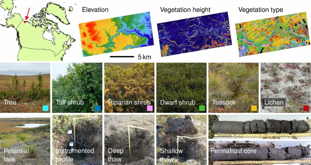
Thawing permafrost at Trail Valley Creek in Canada may bring uncertainty for the entire region: roads and buildings could lose their solid foundations if the ground subsides. Also, the thawing of permafrost everywhere in the world – be it in Canada, Siberia, or other parts of the Arctic – serves as an indicator of global warming.

“Permafrost is a phenomenon that occurs under the surface of the soil, and is therefore difficult to measure,” says Julia Boike of the Alfred Wegener Institute (AWI). Even under coverings of permanent ice, experts believe, there are vast areas in which the ground has irreversibly thawed. These areas of unfrozen ground in permafrost regions are known as talik. Exactly where these are located and how extensive they are, however, is as yet unknown.

This project proposes a method for quantifying the properties of subsurface permafrost. This will reveal how rapidly ground thaw is progressing. The area of investigation is at Trail Valley Creek, located at the forest-tundra boundary in the North West Canadian permafrost zone. The researchers are developing an approach that will combine a physical permafrost model with data newly obtained from aerial images as well as with interferometry, tomography, and polarimetry information obtained from radar data. “We have many datasets from past measurement campaigns, which we want to combine and interpret together in order to learn more about the conditions of the ground,” says Irena Hajnsek of the German Aerospace Center (DLR).

Loading...

Publications


Grünberg, I., Hollenbach Borges, D., Hammar, J., Rutter, N., Marsh, P., & Boike, J. (2025, January 20). Snow on permafrost: the effect of spatial snow variability on soil temperature in Trail Valley Creek, NWT, Canada. https://doi.org/10.5194/egusphere-egu24-17057
Hollenbach Borges, D., Grünberg, I., Hammar, J., Rutter, N., Krumpen, T., & Boike, J. (2025, January 20). Snow accumulation patterns from 2023 Airborne Laser Scanning data in Trail Valley Creek, Western Canadian Arctic. https://doi.org/10.5194/egusphere-egu24-16806
Rettelbach, T., Nitze, I., Grünberg, I., Hammar, J., Schäffler, S., Hein, D., Gessner, M., Bucher, T., Brauchle, J., Hartmann, J., Sachs, T., Boike, J., & Grosse, G. (2024). Very high resolution aerial image orthomosaics, point clouds, and elevation datasets of select permafrost landscapes in Alaska and northwestern Canada. Earth System Science Data, 16(12), 5767–5798. https://doi.org/10.5194/essd-16-5767-2024
Grünberg, I., Groenke, B., Westermann, S., & Boike, J. (2024). Permafrost and Active Layer Temperature and Freeze/Thaw Timing Reflect Climatic Trends at Bayelva, Svalbard. Journal of Geophysical Research: Earth Surface, 129(7), e2024JF007648. https://doi.org/10.1029/2024JF007648
Saporta, P., Alonso-González, A., & Hajnsek, I. (2024). Seasonal comparison of InSAR and PolInSAR observables over a lowland permafrost site. Proceedings of ICOP 2024. 12th International Conference on Permafrost, Whitehorse, Canada. https://elib.dlr.de/202618/
Hammar, J., Grünberg, I., Kokelj, S. V., van der Sluijs, J., & Boike, J. (2023). Snow accumulation, albedo and melt patterns following road construction on permafrost, Inuvik–Tuktoyaktuk Highway, Canada. The Cryosphere, 17(12), 5357–5372. https://doi.org/10.5194/tc-17-5357-2023
Saporta, P., Alonso-Gonzalez, A., & Hajnsek, I. (2023, February). Assessing Polarimetric SAR Interferometry coherence region parameters over a permafrost landscape. POLinSAR Online Abstracts. ESA POLinSAR Workshop, Toulouse, France. https://elib.dlr.de/194470/
Saporta, P., Alonso-González, A., & Hajnsek, I. (2023). Investigating signal penetration depth in Synthetic Aperture Radar imagery over lowland permafrost. In J. M. Fernández-Fernández, J. Bonsoms, J. García-Oteyza, & M. Oliva (Eds.), Book of abstracts (p. 246). https://doi.org/10.52381/EUCOP6.abstracts.1
Hammar, J., Grünberg, I., Hendricks, S., Jutila, A., Helm, V., & Boike, J. (2023). Snow covered digital elevation model and snow depth product (2019), Trail Valley Creek, NWT, Canada. PANGAEA. https://doi.org/10.1594/PANGAEA.962552
Nill, L., Grünberg, I., Ullmann, T., Gessner, M., Boike, J., & Hostert, P. (2022). Arctic shrub expansion revealed by Landsat-derived multitemporal vegetation cover fractions in the Western Canadian Arctic. Remote Sensing of Environment, 281, 113228. https://doi.org/10.1016/j.rse.2022.113228
Saporta, P., Hajnsek, I., Hänsch, R., Grünberg, I., & Boike, J. (2022, May 31). The Hidden Image of Thawing Permafrost: project overview and first results of the radar polarimetric analysis. EPIC3Helmholtz Imaging Conference 2022, Berlin, Germany, 2022-05-31-2022-06-01. Helmholtz Imaging Conference 2022, Berlin, Germany. https://epic.awi.de/id/eprint/56257/
Grünberg, I., Hammar, J., Walker, B., Hajnsek, I., Saporta, P., & Boike, J. (2022, May 31). Mapping Arctic treeline vegetation using LiDAR data in the Mackenzie Delta area, Canada. EPIC3Helmholtz Imaging Conference 2022, Berlin, Germany, 2022-05-31-2022-06-01. Helmholtz Imaging Conference 2022, Berlin, Germany. https://epic.awi.de/id/eprint/56256/
Saporta, P., Hajnsek, I., & Alonso-Gonzalez, A. (2022). A temporal assessment of fully polarimetric multifrequency SAR observations over the Canadian permafrost. Proceedings of the European Conference on Synthetic Aperture Radar, EUSAR. European Conference on Synthetic Aperture Radar, EUSAR, Leipzig, Germany. https://elib.dlr.de/186412/
Gonstalla, E., Grünberg, I., & Boike, J. (2021). Das Eisbuch - Alles, was man wissen muss, in 50 Grafiken. oekom Verlag.
Lange, S., Grünberg, I., Anders, K., Hartmann, J., Helm, V., & Boike, J. (2021). Airborne Laser Scanning (ALS) Point Clouds of Trail Valley Creek, NWT, Canada (2018). PANGAEA. https://doi.org/10.1594/PANGAEA.934387
Saporta, P., Alonso-González, A., & Hajnsek, I. (n.d.). Analysis of Pol-InSAR coherence region parameters over a perma- frost landscape.
Rolf, M., Grünberg, I., Hammar, J., Brauchle, J., Hauber, E., & Boike, J. (n.d.). Widespread and long-term permafrost thaw subsidence on the Brøgger peninsula, Svalbard. Retrieved February 14, 2025, from https://www.authorea.com/users/871506/articles/1252407-widespread-and-long-term-permafrost-thaw-subsidence-on-the-br%C3%B8gger-peninsula-svalbard

Other projects


Image: DLR

TerraByte-DNN2Sim

On the trail of the mystery of the laws of calving

Researchers still face a mystery when it comes to the laws by which glaciers calve. This project aims to use satellite imagery, artificial intelligence, mathematical optimisation and a new data processing pipeline to track the movements of glacier fronts in Antarctica to get closer to solving the mystery.
 

Hyper 3D-AI

Artificial Intelligence for 3D multimodal point cloud classification

The aim is to develop an artificial intelligence that can achieve the fusion of two-dimensional data with three-dimensional information. Based on this, the software would simultaneously be able to recognise image characteristics as well as the spatial relationships between different objects.
 

MultiSaT4SLOWS

Multi-Satellite imaging for Space-based Landslide Occurrence and Warning Service

In order to detect impending landslides before they occur and to enable reliable emergency mapping after a landslide, the researchers are combining optical data with radar data from satellites. Using machine learning methods, computers will be trained to recognise the tiniest of changes in things like sloping landscape surfaces.