MultiSaT4SLOWS
Multi-Satellite imaging for Space-based Landslide Occurrence and Warning Service
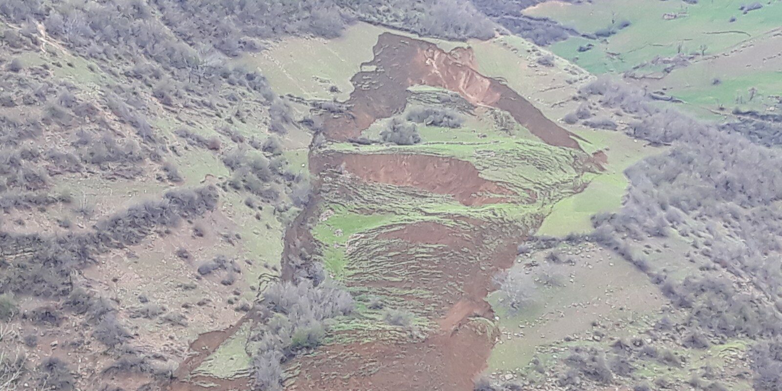
“We are working with satellite data for this,” says Prof. Dr. Mahdi Motagh of the Helmholtz-Centre Potsdam – GFZ German When a landslide occurs, it often comes as a complete surprise – despite the fact that, in most cases, slopes only gradually pick up speed after a long period of initial creep. This project aims to develop a method that detects even the tiniest of changes in the earth’s surface. Such a method would then provide the basis for early warning systems and for rapid emergency mapping if it ever comes to a landslide.
Research Centre for Geosciences. Satellite photos have long been used in practice, but there are many problems to this: if a region of concern is under a layer of cloud cover, it can take days or even weeks for the clouds to part and allow the satellites to take useful photos of a torrential rain or flood event, for example. “We are therefore working with radar images from satellites, since radar delivers reliable images irrespective of the weather,” Mahdi Motagh explains.
They will now be developing an automated method to be tested in example regions in China around the Three Gorges dam, in Kirgizstan, and in Iran. The key to the approach is data fusion: radar data and optical satellite images will be combined to map the status quo and subsequently to detect even the slightest of changes. “The radar images are on such a fine scale that they can detect movements in the order of centimetres or even millimetres, as well as minor changes in vegetation, resulting from a landslide,” says Mahdi Motagh. Computers will be trained using machine learning methods to recognise these miniscule changes.
Other projects
3DforestSIF
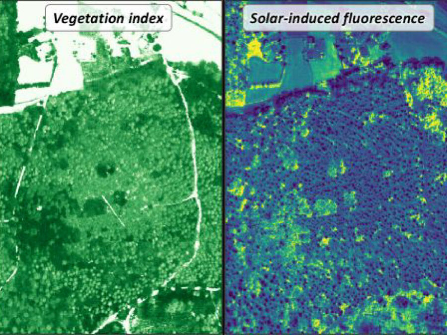
Understanding the solar-induced fluorescence (SIF) signal of natural, complex tree canopies
3DforestSIF seeks to correct airborne solar-induced fluorescence (SIF) data from forests for canopy structural and illumination effects, providing valuable insights for the early detection of forest stress.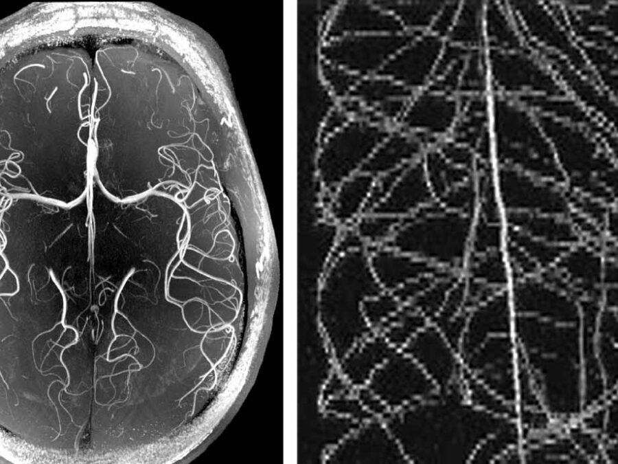
HighLine
High Image Quality for Lines in MRI: From Roots to Angiograms
MR images of roots and vessels are very similar: both display thin, line-like objects. The aim of the project is to increase image quality of both kind of MR data by exploiting their similarity. HighLine aims at obtaining high quality images in reduced scan time to lower patient burden and increase patient and plant throughput by adapting state-of-the-art 3D image enhancement methods, and developing new deep-learning based methods.
NImRLS
Neuroimaging Biomarkers for Restless Leg Syndrome
The aim is to develop a software solution that can analyse enormous amounts of data on tens of thousands of subjects from large-scale health studies. Using restless leg syndrome as an example, genomic data will be combined with neuroimaging data in order to identify new biomarkers with the help of machine learning methods.